 |
| April 4, 1974 |
April 3, 1848 - Town seal adopted
April 8, 1848 - Brookline branch railroad opened to public
April 6, 1960 - Dr. John Rock and birth control pill
April 4, 1974 - Town votes to acquire Hall’s Pond
April 3, 1848
Town seal adopted
 |
| Town Seal |
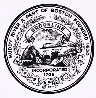
Brookline Town Meeting voted to accept the now ubiquitous Town Seal. It was described as picturing "a group of agricultural and farming implements, a view of the City of Boston in the distance, with a train of cars running between the two places" and bearing the inscription "Muddy River, a part of Boston. Founded 1630. Brookline incorporated 1705."
The design, according to a report from then Town Clerk Artemas Newall, was "intended to be emblematical of the character of the Town from its early settlement, when designated and known as Boston Cornfield & Boston Plantation, to the present time,— the inscription to perpetuate, in a degree, its early historical associations."
The symbolism, according to a report from the town Preservation Office, "asserts that Brookline was not just suburban but prosperously agrarian—a suitable home, perhaps, for the country gentleman." The seal, engraved on steel, was executed for the town by Francis N. Mitchell of Boston at a cost of $56 which included 100 embossed impressions and a press to be used for copying.
For more on what is pictured on the seal, see What's That on the Town Seal?
April 8, 1848
Brookline branch railroad opened to public
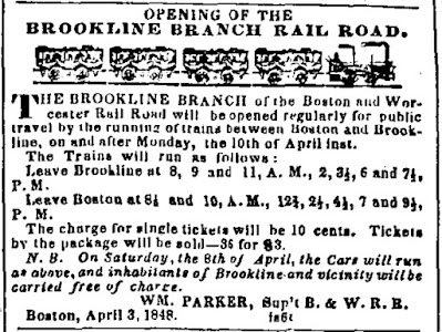
Residents of Brookline and surrounding communities were given a free preview of the new Brookline branch of the Boston and Worcester Railroad, two days before its official opening on April 10th.
 |
| This notice about the opening of the Brookline branch of the Boston and Worcester Rail Road appeared in the Boston Semi-Weekly Advertiser on April 3, 1848 |
The Boston and Worcester -- Massachusetts' first passenger railroad -- was chartered in 1831 and opened its first branch, to West Newton, in 1833. Tracks to Worcester were completed in 1834, and the original single track was replaced by a double track between 1839 and 1843.
 |
| This sketch of the locomotive used on trains between Brookline and Boston was made by Frank Kimball Rogers in 1930 |
April 6, 1960
Dr. John Rock and the birth control pill
Brookline's Dr. John Rock, one of the key figures in the development of the birth control pill, told a meeting of the American College of Obstetrics and Gynecology in Cincinnati that he believed the pill, which was based on the natural rhythms of the body, would be an acceptable method of birth control for Catholics.
Rock, who lived on Pill Hill and did much of his work at the Free Hospital for Women on Pond Street, was a devout Catholic who reportedly attended mass at St. Mary's of the Assumption in Brookline every day. In 1931, he had been one of 15 doctors -- and the only Catholic -- to sign a petition urging repeal of Massachusetts’ prohibitions on sharing contraceptive information. In 1949 he had co-authored a book called Voluntary Parenthood that explained different methods of contraception for a lay audience.
 |
| Dr. John Rock at St. Mary's Church. Life magazine, "A Catholic doctor speaks up," May 10, 1963 |
Rock was devastated when, in 1968, Pope Paul VI ruled against all forms of birth control except the rhythm method. Around the same time, he lost his clinic due to hospital mergers, Harvard politics, and other changes. In 1971, he moved to NH to live with his daughter. He died there in 1984.
April 4, 1974
Town votes to acquire Hall’s Pond
Town Meeting voted to authorize the Select Board to purchase or take by eminent domain an area of approximately 3.5 acres around Hall's Pond. It was also voted to appropriate $82,000 to acquire the pond and $20,000 to prepare it for "passive recreation."
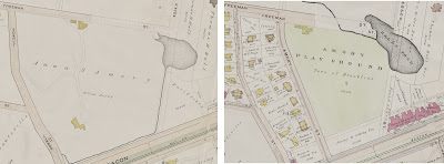
Hall's Pond was once part of the Cedar Swamp wetland. The swamp and its marshy outflow were largely underdeveloped until after the Civil War. By stages, Cedar Swamp was filled in until all that remained was a one-acre pond called Swallow Pond that was used largely as a storm drainage pit for the surrounding area.
 |
| The Hall's Pond / Amory Park area as seen on the 1893 and 1907 atlases (Click image for larger view) |
For much more on the history of Hall's Pond, including more maps and photographs, visit the Friends of Hall Pond website and its history section.
No comments:
Post a Comment